Erne Guide II ©
40
Dies ist der Stand am Portora
Lock bisher
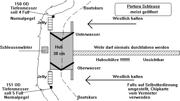
Dies ist
ab sofort der neue Stand am Portora Lock (1.8.10)
Siehe
weiter unten
Ab jetzt
können Sie am Südpegel (Schleuse stromaufwärts) den Wert am Wasserlevel ablesen
und den zum SNL (150 Fuß OD) (Summer Normal Level) addieren und schon haben Sie
den aktuellen Ist Wasserstand.
Beim
Nordpegel (Schleuse stromabwärts) können Sie den Wert ab Herbst ablesen und
auch zum SNL (147 Fuß OD) addieren und dann haben Sie ebenso den aktuellen Ist
Wasserstand.
Der
Nordpegel hat jetzt noch eine Differenz von 1 Fuß! Ist also falsch!
Sofern die
Schleuse offen ist, muss der Wasserstand an beiden Pegeln gleich sein!
Beispiel:
Südpegel zeigt 1 Fuß an und Nordpegel 4 Fuß
(ab Herbst),
dann ist
der Ist Wasserstand bei offener Schleuse sowohl im ULE, als auch im LLE bei 151
Fuß OD.
The levels of the two loughs are set by
law, the minimum of LLE is 147 feet related to Poolbeg lighthouse in Dublin Bay
and ULE has to have a minimum of 150 feet to the same datum.
Unfortunately the downstream gauge at
Portoa locks (the north gauge) was incorrectly set to 146 feet many years ago
and as a result reads 1 foot too low. I intend to change it this Autumn so that
it reads correctly.
The upstream gauge (the south gauge) is
correct and will give you the water level if you add the gauge reading on to
150 feet.
During the Autumn I also intend to put
post gauges at a few bridges round the loughs so that people can easily read
the level. These gauges will all most likely give a direct reading to Poolbeg ,
ie they will actually read for example 152 feet 5 inches.
Hi and all,
as I mentioned in an earlier post, the depths on the Lough Erne Outdoor
Pursuits Maps are the depths at the lowest possible water levels, which are
44.81 (Lower Lough) and 45.72 (Upper Lough and above Portora), both figures to
Poolbeg datum, which in the legislation are 147' and 150' respectively.
Converted to Belfast datum, these would be 42.00m and 42.90m respectively,
which are the datum levels given on your chart. However, we work to Poolbeg
datum and have done so for the last 130 odd years. No, I don't remember when we
started.
Therefore, as generation stopped completely on 6 June in anticipation of this
long dry spell, the Lower Lough is not particularly low, at around 45.75
Poolbeg, or somewhat above the middle of its range, despite what the press say.
Granted, the Upper Lough is suffering, we have rarely had such a prolonged dry
spell, but as I said earlier, there is no solution other than to build two more
control weirs. There should therefore be around 1metre more water in the Lower
Lough than your charts indicate, so no problem round Devenish, but the Kesh
river might still take extra care as I don't think WI have dredged it recently.
When Lt James Wolf surveyed the loughs in 1836 or so
the standard Ordnance Datum had not yet been established. It was only in the
1850s that the Ordnance Survey triangulated in the levels from Poolbeg. I do
have the relationship between the depths/heights on the Admiralty Survey to
those of the Ordnance Survey, but they are in the office and may take a few
days to find. The two were not actually correlated until about 1950, when the
same point on Devenish Tower was used to relate and validate both surveys. I’ll
see if I can find the relationship but I’m fairly busy at work at present so
may not have much time for the lighter side for a few days. The fixed stones
from the 1890s Price drainage scheme may not now be in their original
locations, I’m afraid I don’t know definitely, certainly the one I have at my
office door is reading several tens of feet wrong, but there are slight errors
apparent between modern day surveying techniques using satellites to those
established using optical instruments. They are not of a massive scale, usually
less than 1 foot (300mm) but nevertheless they are there. The lock wall at
Portora was surveyed in 1955 to a height of 154 feet OD Poolbeg using optical
instruments and we relate everything else on the loughs to that fixed, known
and accepted level.
Bear in mind that the Admiralty (Royal Navy) was
primarily interested in water depths rather than ground heights! Although they
did pick up some prominent hills so that readings could be taken using a
sextant.
Finally,
the old stone markers used decimal portions of a foot long before their time in
the United Kingdom. 152 and 66 inch is actually 152.66 or 152 feet 8 inches. I
think this may have done to a) prove how clever they were and 2) to confuse
those who had at that time not the slightest clue about decimalization!
Eine
Computerübersetzung des o.a. Textes:
Als Lt
James Wolf befragten die Loughs im Jahr 1836 oder so die Standard-Ordnance
Datum noch nicht festgelegt. Erst in den 1850er Jahren, dass der Ordnance
Survey in den Ebenen von Poolbeg trianguliert. Ich habe die Beziehung zwischen
den Tiefen / Höhen auf die Admiralität Survey denen der Ordnance Survey, aber
sie sind im Büro und kann ein paar Tage dauern, um zu finden. Die beiden waren
eigentlich nicht korreliert, bis etwa 1950, wenn der gleiche Punkt auf Devenish
Tower verwendet wurde, beziehen und zu validieren beiden Erhebungen. Ich werde
sehen, ob ich die Beziehung finden, aber ich bin ziemlich beschäftigt bei der
Arbeit derzeit so kann nicht viel Zeit für die leichtere Seite für ein paar
Tage. Der feste Steine aus den 1890er Jahren Preis Drainage System kann jetzt
nicht mehr in ihren ursprünglichen Speicherorten werden, ich fürchte, ich weiß
nicht definitiv wissen, sicherlich das, was ich habe an meiner Bürotür liest
mehrere Dutzend Meter falsch, aber es gibt leichte Fehler scheinbare zwischen
modernen Vermessungstechnik mit Satelliten, um diesen Sitz mit optischen
Instrumenten. Sie sind nicht von einer massiven, meist weniger als 1 Fuß (300
mm), aber dennoch sind sie da. Die Sperre Wand Portora wurde im Jahr 1955 bis
zu einer Höhe von 154 Meter OD Poolbeg mit optischen Instrumenten und wir
beziehen alles andere auf der zu befragenden Loughs dieser festen, bekannten
und akzeptierten.
Berücksichtigen
Sie, dass die Admiralität (Royal Navy) war in erster Linie in Wassertiefen
anstatt Boden Höhen interessiert! Obwohl sie es abholen einiger prominenter
Hügel, so dass Lesungen könnten getroffen werden, mit einem Sextanten.
Schließlich
verwendet die alte steinerne Marker decimal Teile eines Fuß lange vor ihrer
Zeit in das Vereinigte Königreich. 152 und 66 Zoll ist eigentlich 152,66 oder
152 Fuß 8 Zoll. Ich denke, das kann a) beweisen, wie clever sie waren und 2)
diejenigen, die damals nicht die geringste Ahnung hatte decimalization
verwechseln getan haben!
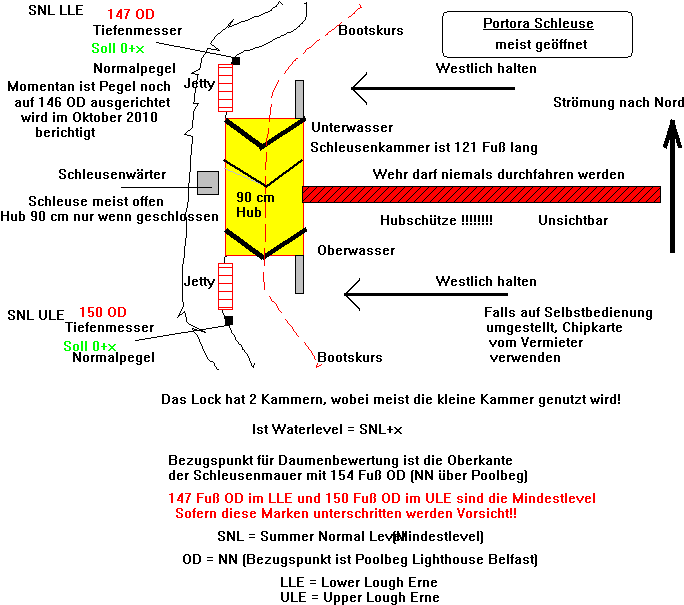
Zur Schleuse selbst gibt es noch eine wichtige Erklärung, die 3 Tore erlauben die Schleuse auch als Doppelschleuse zu verwenden, also bei extremen Leveldifferenzen kann in zwei Stufen geschleust werden. Die Erbauer des Wasserkraftwerkes in Ballyshannon mussten eben alle Möglichkeiten bei einem damaligen Cross-Border Projekt berücksichtigen.
Die 3 Schleusentorpaare haben folgenden Nutzen oder Vorteil. 1.Jedes Paar kann im Service oder Reparaturfall aus der Funktion genommen werden. 2. Die Kammern können von 13 bis (eine Kammer) bis 22 m nutzbare Länge (andere Kammer) und komplett 37m nutzbare Länge beide Kammern zusammen ausgedehnt werden. Wer den Bojenleger im Bootsjargon "Piratenschiff" bei Portora schon gesehen hat, kann dies gut nachvollziehen. Natürlich sind Wassereinspareffekte auch ein Thema.
Ansonsten bin ich der
Meinung vom Erneexperten Udo Vogel,
ergänze noch, dass die kleinere Kammer schneller geflutet und gelenzt werden
kann, deshalb kann man die Kammern den Schiffsdimensionen anpassen.
Vergessen wir aber bei all
den Diskussionen nicht, dass der Urpegel am Manor House steht und dort wurden
einmal 152 Fuss und 6,6 Inch angezeigt.
(1 Fuss = 12 Inch). Die OD’s (Seehöhe oder NN)
in den OSNI Karten beziehen sich auf die Tide in Malin Head.
Im Erne Guide II© sind noch andre Indikatoren für den Wasserstand festgehalten.
___________________________________________________________________________
Copyright 1995-2010 by R.J.Steinacher, Germering (IWS Verlag)